
Rangitatau - Poito and Oruati -Te Tangihanga o Kupe PrecinctMaori Sites of Te Whanganui a Tara |  |
Rangitatau - Poito and Oruati - Te Tangihanga o Kupe Precinct
Whetu Kairangi pa site on Seatoun heights provides a link between the ancient past and the present, being the place where Toi's great grandsons, Tara and Tautoki are said to have built their pa and their houses, the first in the district. One house was named Raukawa after the water now known as Cook Strait, the other called Wharerangi, after an ancient house from Hawaiki. The spring there was called Te Puna o Tinirau, after a place in the ocean where whales are said to originate. Here began Ngai Tara.
The pa was named Te Whetu Kairangi, because its inhabitants saw no other tribes, and dwelt with a view only of the stars at night. When the fort was finished, Tara's wife Te Umuroimata said to Tara: "You should give your name to
the harbour," to which Tara agreed. Thus it was named Te Whanganui a Tara (Great Harbour of Tara).
Among the cultivation grounds were Kirikiri Tatangi (Seatoun Flat), on the eastern side of Te Whetu Kairangi.
It was Hinekiri who named today's Miramar Peninsula, Motu Kairangi, then an island strategically separated from the mainland by a body of water, Te Awa a Taia, which was displaced within Maori memory by earthquake uplift. Thus the pa is said to have given its name to the land.
Just off Seatoun is Aroaro o Kupe, sometimes Te Ure Kupe, said to be the place where Kupe injured himself while swimming.
Another stockaded village was Oruaiti Pa, on the ridge above Seatoun which Elsdon Best using Coutts Crawford's information suggested was at some stage occupied by Rangitane - Crawford argued that Rangitane may have been the original people living on the site.
Angela Ballara's analysis is that in the early eighteenth century Kaingakiore, of Ngati Kahukuraawhitia (a major descent group in the Wellington area Hawkes Bay originated descendants of Toi intermarried with Ngäti Kahungunu and later after moving to the Wairarapa with Ngai Tara and Rangitane) and Ngäti Ira descent controlled the Miramar peninsula. It may have been during his lifetime that it became deserted following a series of perhaps 10 battles against Ngäti Apa and Whanganui attackers which Crawford writes were won by Ngäti Kahukura-awhitia but which, in the decisive victory, the local chief Kaingakiore was killed.
Sources
1. Adkin, Leslie, The great harbour of Tara, (1959).
2. A Ballara "Te Whanganui-a-Tara: Phases of Maori Occupation of
Wellington Harbour c. 1800-1840" in The Making of Wellington ed D Hamer, R Nicholls 1990
3. J C Crawford, "Notes on Miramar Peninsula, Wellington Harbour"
Transactions of the NZ Institute vol 5 p 396 1873
4. Elsdon Best "The Land of Tara" Journal of the Polynesian Society vol
26, vol 27, vol 28
5. J McEwen Rangitane
Poito PaLocation: At the head of Tarakena Bay, near Wellington Heads, on a low spur, above the Te Poti stream on its western side.Type of site: Pa, once heavily terraced and palisaded Known iwi/Hapu connections: Ngäi Tara, Ngäti Ira Condition : Not known. | 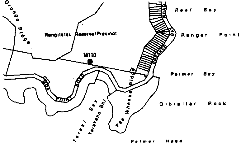 |
Sources
1 . Adkin, Leslie, The great harbour of Tara, (1959). p 67; Best, E, Miramar and its history' Transactions NZ Institute, vol 54; Crawford, JC, Notes on miramar Peninsula, Transactions NZ Institute vol 45.
2. Christie H, 'Rangitatau Pa,' JPS Vol 52, 1943
3. Best p. 6
Rangitatau Pa
Location: above Tarakena Bay, on the pinnacle of the bluff west of Te Poti StreamType of site: Pa
Known iwi/Hapu connections: Ngäi Tara
Condition : Good in 1960.
Tuteremoana of Ngäi Tara is said to have lived there, the principal house being named Raukawa. When visited by HM Christie in 1899, traces of the site were plainly visible and charred remains of totara palisading were still in the ground. The nearby fortified village of Poito used Rangitatau as a citadel in times of stress. A large shell midden at the foot of the hill below Rangitatau citadel yielded many artifacts, and stone anvils were found beside Te Poti stream. (1)
Both were destroyed by raiders from the north 1819-20. Led by Tuwhare, the Toa killed people from the pa working in nearby kumara fields Te Urahi and Puahu of Ngäti Rangi Te Wawapo of Ngäti Ira, Takatua of Ngäti Rakai and a number of others, including Pauata, Kopani, Te Rongarua, Puakato, Hungahunga, Koroua and Huatoki, all men. Women slain were Huirua, Te Arahe, Pukurua, Te Koki, Te Rehu, Tangiaru, Hineuhi and Tihitihi. In all some 50 died.
As well as Poito and Rangitatau, the raiders destroyed Te Kopahou, the pa of
Ngäti Rangi and Ngäti Hikerata, but there was a retaliatory raid. (2)
At the turn of the century this was the best preserved pa site in Miramar. Terraces and ditches remain, standing out clearly. Tarakena Bay was probably a canoe landing site. (3)
Sources
1. Adkin, Leslie, The great harbour of Tara, (1959). p 74; Best, Pt 6 p 174; Best, E, Miramar and its history' Transactions NZ Institute, vol 54; Crawford, JC, Notes on miramar Peninsula, Transactions NZ Institute vol 45, McEwen, Rangitane pp 38-40 ; NZAA N164/3 (R27/55)
2. Christie, H, 'Rangitatau Pa,' in JPS Vol 52, 1943
3. Best, p 6
Palmer Head/RangitatauLocation: Palmer Head.Type of site: Pa Known iwi/Hapu connections: Not known, possible Ngäi Tara Condition : Some disruption around 1990 through council works and motorbike use, now rectified. | 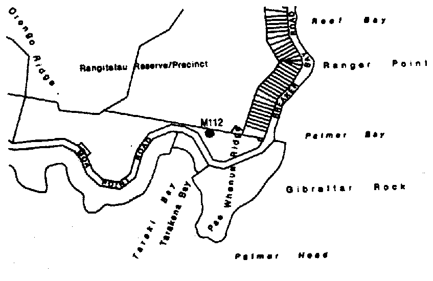 |
Best observed
"The old men have told us that one of the pa or fortified villages of Tara,
known as Rangitatau, was situated on the western side of the entrance to Port Nicholson, opposite Pencarrow Head. It was probably either on the hill at Palmer Head, or [at Tarakena]. On both of these hills are to be seen signs of old time occupation". (1)
"This point ... shows a number of hut sites, now much eroded, but still recognisable. On the eastern side of the extremity of the spur is a ditch-like depression that may be an old entrance way from the beach below ... Hut sites also seem to be in evidence further up the spur." (2)
Adkin puts the pa at Tarakena, not Palmer Head. (3)
Archaeological records exist for a midden lying on either side of the formed road from Moa Point to Palmer Head. Shell and fishbones as well as oven stones, charcoal and stone flakes have been found there. The site was disrupted by council roadworks and motorbike use, but is now protected. (4)
Sources
1. Best, E. JPS, Pt 2 p 8
2. Best JPS Pt 6 p 7. See also Best 'Miramar Island and its History'
Trans of NZ Inst, Vol 54, Crawford JC, Notes of Miramar Peninsula, Trans of NZ Inst, Vol 45
3. Adkin detailed map p 83
4. NZAA N164/106
Te Aroaro-o-KupeLocation: Pinnacle Rock, offshore from Seatoun.Type of site: Coastal rock Known iwi/Hapu connections: Multiple Condition : Natural feature. |  |
"Our seafarers ...entered the harbour, landing at Seatoun, the foreshore of which place is known as the Turanga-o-Kupe, possibly so named from the fact that the sea rover was hurt against a rock when bathing at the Pinnacle Rock, known as the Aroaro-o-Kupe." (1)
"Kupe, the Explorer, injured himself on this rock while swimming there, hence the name, which means the front of Kupe,' and its variant, Te Ure-o-Kupe, which indicates the place of his injury." (2)
Sources
1 . Best JPS Pt 1 p 146. See also brief reference to "the Pinnacle Rock off Seatoun," at Best Pt 5 p 174
2. Adkin p 13. Williams' Dictionary confirms this meaning of "aroaro". Adkin also notes S Percy Smith and JC Anderson in their maps mislabelled the feature as Barrett Reef. Adkin map p 115. See also Crawford, Best Trans of NZ lnst as for above.
Oruaiti PaLocation: Point Dorset.Type of site: Pa, and kainga Known iwi/Hapu connections: Rangitane Condition : Largely destroyed (1) | 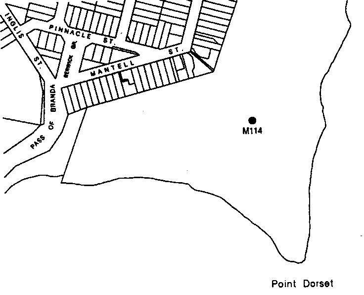 |
Fort Dorset now occupies the site of Oruaiti pa, one of the old stockaded villages of past centuries. Prior to being interfered with the ridges showed many levelled hut sites, sufficient to accommodate about fifty huts. A number of water-worn boulders scattered about were probably used as blocks on which to pound fern root, and for other purposes. Butts of posts, one of which is in the Newtown Museum, were found here, as also stone flakes and other tokens of former occupation. Some information concerning this place, and other matters pertaining to Hataitai are contained in the works of Jas. Mackay and Canon Stack. At one time Oruaiti is said to have been occupied by Rangitane folk." (2)
"An old time stockaded village on Point Dorset." (3)
The name signifies the place of 'small hole [or pit].' Crawford says Rangitane people occupied it and were supposed to be the original builders, but it was later taken over by other tribes. (4)
McLeod published a sketch of Orua-iti, depicting it as a palisaded village on the eastern cliff-margin on the flat top ridge above Dorset point(5). McLeod refers to its occupation in "Maori and pre-Maori times," and a lengthy period of occupation is confirmed by Crawford." (6)
Possibly originally occupied by Rangitane (founder, Te Rerewa) (7). Later occupied by other tribe" (8).
In 1974 an oven stone was found near a concrete gun emplacement on this site(the emplacement has since been removed). This suggests it might have been the location of a kainga or pa. An archaeological dig at the fort in 1992 at the site of roadworks found very decayed shells in a band 20-39cm below the present ground level. (9)
Sources
1. WCC Maori Historical Information, Site Handbook, 1990
2. Best, Pt 6 p5
3. Best, Pt5 pl74
4. Crawford 29, p 398
5. Adkin p 55. See sketch plate 5, McLeod's map with sketch, from
McLeod p 38. Adkin maps the site at p 115
6. Crawford 29, p 378
7. McEwen J, Rangitane - A Tribal History
8. WCC Maori Historical Information, Site Handbook, 1990 (not sourced)
9. NZAA N 164/113, NZAA R27/194, NZAA R27/115
Te Turanga-o-KupeLocation: Seatoun, on-shore from Pinnacle Rock.Type of site: Landing area Known iwi/Hapu connections: Not known Condition : Affected by Hau-Whenua earthquake approx 1450. | |
Adkin repeats a Best commentary but adds as follows:
"The foreshore [or place on it where Kupe stood after landing] at Seatoun and the stretch of water between it and Pinnacle [or Steeple] Rock [where he went swimming]." (1)
Adkin adds "Remembering that in Kupe's time Miramar was an island ...entirely hilly and without any fringing flat land or broad beaches at Seatoun or elsewhere...Kupe's landing place must have been at what is now the rear of Seatoun flat (Marae-nui, q.v.). This fact does not alter the accuracy of the tradition in any way; it merely serves to correct our impression of the local conditions at that remote period. Kupe probably landed on an abrupt shore just inside the northern end of the Point Dorset subsidiary hill-ridge and stood
turanga) surveying his surroundings from that spot before swimming out to Steeple rock...and injuring himself on its harsh and rugged edges." (2)
Sources
1. Adkin, Leslie, The great harbour of Tara, (1959). p 89; Best Pt 5 p 174
2. Adkin, p 90
Korero o te Wa I Raraunga I Rauemi I Te Whanganui a Tara I Whakapapa