

Wellington District Deeds - No. 4
Te Aro (Colonel McCleverty's Deed), Wellington district.
Also available — scanned images of No. 2 Plan and No. 3 Plan.
22 March, 1847.
Exchange for other lands
We the undersigned Land owners and Chiefs residing at and belonging to Te Aro in Wellington of the Ngatiawa and Ngatirunui Tribes agree on the twenty-second day of March One thousand eight hundred and forty-seven, to give up to Her Majesty's Government All those Cultivations which we have hitherto had on Sections in the Karori, Ohiro, and Kai Wara Districts or elsewhere belonging to European Settlers, on our receiving from the Lieutenant Governor, portions of Blocks of Land which we have seen and accepted, as shown and coloured red on Plans 1, 2 and 3, which accompany this, containing in all 526A. 1R. 31P and the boundaries of which are therein described. Also two Horses and two Carts with Harness complete, and two Steel Mills.
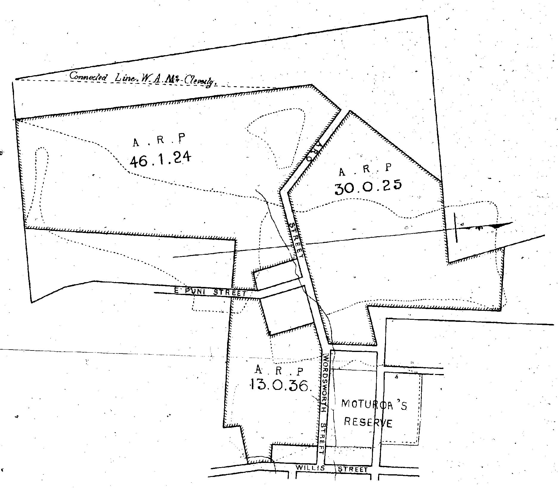
No. 1 Plan shows the Cultivations in and about Polhill's Gully, which were guaranteed by Governor Fitzroy principally on Native Town Reserves, and the Town Belt, the whole contained in one Block and bounded (streets intersecting) as delineated, containing 89A 3R 5P.
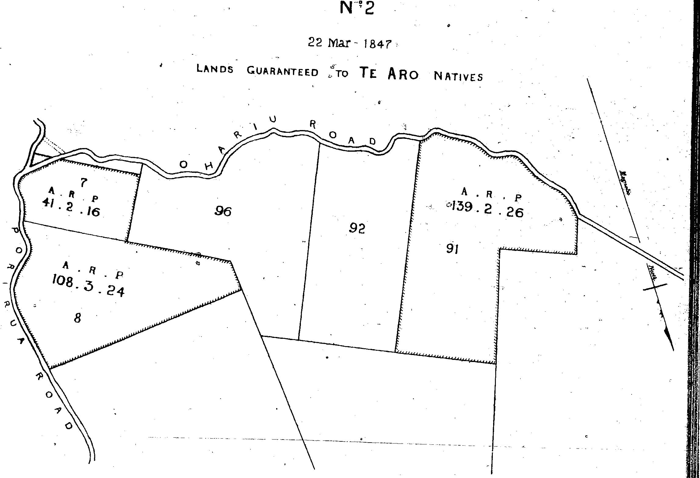
No. 2 Plan describes part of the Native Reserve 7 and the whole of 8 Kinapora District, also Native Reserve 91 in the Ohariu District to the North of which is Unsurveyed Land, the whole containing 290A 0R. 26P.
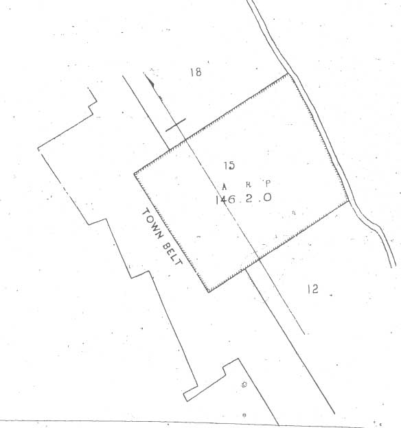
No. 3 Plan describes a Block of 146A. 2R. OP. and is in the Ohiro District consisting of No 15 Native Reserve in that District and about 30 acres of the Town Belt, containing 146A. 2R. 0P.
No. 1 Plan includes 89A 3R 5P as follows Town Sections 1,2,3,4,5,6,7,8,9,10,11,12,13,14,15,16,18,20,22,24,25,26,
27,28,37,39,41,43,45,49, and by a line being the prolongations of the Southern boundary of Section 28 to a point at the distance of one chain or thereabouts from section 49 on the Western boundary of No. 50, containing in all about 4A. 0R. 36P. Part of the Town Belt included within the following boundaries on the West by a line drawn from the South Western Angle of No.1 Town Reserve to the Angle formed by Nos. 10 and 11, Ohiro District, on the North by the boundary lines of Town Reserves 1, 3, 5, 7, 9, 10, 11, and 13. On the East by the boundary line of No. 26 Town Reserve, and nos 29,31,33,and 35 Town Sections prolonged, til it meets Section 11 Ohiro District. On the South by boundarv line of No. 11 Ohiro District extending from the above point to the angle of meeting of Nos. 10 and 11 containing 36A, 1R, 24P. Also part of the Town Belt included within the following boundaries. On the South by the boundary lines of Town Reserves 2, 4, 6, 8, 12, 14, 16, 18, 20, 22. On the East by a line drawn from the junction of Reserves 22 and 24 to a point of one and a half chains East of the angle made by the Southern and Western boundary lines of No. 438 Town Section on the North by a line due East as far as No. 28 Section Karori District - the boundary then runs Southerly and Westerly along the line of the same 28 Section till it meets a point about 9 chains distant in the Westerly direction when the North Western line of No.2 Town Reserve is prolonged and joins the North Western boundary containing 18A. OR 25p.
No.2. Plan contains two Blocks, 290A. OR. 26p. One bounded on the East by the Porirua Road commencing at a point about 8 chains from the present Ohariu Road, and one chain from the old one, and between them until it meets the section occupied by Mr Frank Johnstone. On the North by the edge of Mr Johnstone's fence prolonged to a point about 6 chains from the North Eastern corner of Section 96 Ohariu District, thence by the boundary of that section Southerly and Easterly - Easterly and Southerly to a point about one chain distant from the Ohariu Road. On the South by the boundary line of No.7 Section as shewn. The Block consists of part of No. 7 Section Kinapora District containing 41A. 2R. 16p and No. 8; Section same District containing 150A. 3R 24p. Total, 150A. 2R. OP. the other Block consists of No. 91 Section Ohariu District now containing 139A 2R 26P or thereabouts which may be increased into the unsurveyed Land to the North. No. 2 Plan contains 290A OR. 36p.
No.3 Plan includes 146A. 5R. OP. viz. One Block consists of a Native Reserve, No. 15 Ohiro District containing about 114 acres, and about 32 Acres on the Town Belt, it is bounded on the North by No. 18 Section Ohiro District and the Town Belt. On the East by the road to Ohiro. On the South by No. 12 Section Ohiro District and the Town Belt, and on the West by the Town Belt.
To which we the undersigned jointly and severally agree and write our names in
token thereof the day and year before written.
W.A. McCLEVERTY, Lt. Colonel.
| Ko te tohu x o te Pakuahi | Na Te Wehi |
| Na Mohi Ngaponga | Na Paora Tuwhare |
| Na Hemi Parai | Na Pimipi Haukoteri |
| Na Wi Kingi Te Awitu | Na Te Manihera Paura |
| Na Horomona Te Raro | Na te Retimana Pukahu |
| Na Rawai Te Tawero | Na Humene |
| Na Herekana Mahoe | Na Ngaparu Te Raro |
| Na Raniera Tora | Na Paihika Te Ngo |
Ma motou mo o matou tangata i tuhia ai o matou Ingoa.
Ko te ingoa o nga tangata o te hapu o Ngati kura e noho ana ki te Aro.
| Tamati Wiremu | Te Wunu Ohiro |
| Ngapaka | Ihaia Aurutu |
| Te Teira | Hori Pipi |
| Rawiri Ta Rao. |
Konga Titiro -
Ka Timote Te heheu
Hemi Tahana Niwa
H. Tacy Kemp.
An additional house to be given signed the 24th day of April, 1857.
W.A. McCleverty, Lt. Colonel.
M. Richmond, Supt.
H. Tacy Kemp.
Their Pah is also guaranteed to them vide map attached containing 2 Acres 1 rood, 11 perches.
W.A. McCLEVERTY, Lt. Colonel.
Maori translation
Ko matou ko nga Tangata ko nga Kaumatua o Ngatiruanui o Ngatiawa e noho nei i Te Aro i Poneke ka whakaae inaianei i te rua tekau ma rua o nga ra o Maehe i te Tau kotahi mano e waru e wha tekau ma whitu kia tukua tonutia atu a matou Tae kai katoa, e takoto ana i waenga o nga whenua o nga Pakeha, ara - ko nga Tae kai o "Karori" - o "Ohira" - o Kai "Wharawhara" o whea noa atu Ko aua Tae kai kotoa e takoto ana i waenganui o nga oneone o nga Pakeha ka whakaaetia nei, kia tukua whaka reretia atu - hei utu mo nga whenua tinana kua tukua mai nei mo matou e Kanara Makaraweti (Lt. Col. McCleverty) ara e raua ko Kawana kua kite nei o matou kanohi kua oti nei matou te whakawhiwhi - he mea pani ki te Ta whero i roto o nga Pukapuka apiti o tenei. He mea maka ki te tahi ki te rua ki te toru o nga whika nui huia e Rima rau e rua tekau ma ono o nga eka kotahi Rure - kotahi Paehe ko nga rohe oti katoa te ata whakatakoto ki roto i nga Pukapuka - Apiti mai hoki ki enei whenua - e rua nga Hoiho e rua nga kata - me nga mekameka katoa - e rua hoki nga mira huri witi heoti - kei roto o te pukapuka tuatahi ko nga Tae kai e takoto haere ana i roto i te awaawa i te kainga o Porera - ko nga Tae kai enei i tukua iho ki a matou e Kawana Pitiroi imua ko te nuinga kei roto pu kei nga wahi Rongoa o mua kei te whenua i runga ake o te Taone - Engari ko nga Tae kai i waenganui o nga whenua o nga Pakeha - ka tukua atu mo tetahi wahi whenua i runga ake o te Taone kotahi tonu te tinana whenua - huihuia e waru tekau ma iwi o nga Eka e toru o nga Rure ko tahi te Paehe - kei te pukapuka te rohe - kei roto kei te pukapuka tuarua ka wahi etahi o te whenua rongoa o mua he mea maka ki te whitu o nga whika ko te waru o nga whika ko te whenua katoa o Kinapora ko te whenua rongoa o mua he mea maka ki te iwa tekau ma tahi o nga whika i Ohariu - huihuia e rua rau e iwa tekau o nga eka - e rua tekau ma ono o nga paehe - Kei te toru o nga Pukapuka kotahi te whenua tinana kei Ohiro - huihuia te nui kotahi rau e wa tekau ma ono o nga Eka e rua nga Rure - kotahi te whenua Rongoa o mua kotahi tekau ma rima te tohu - Apiti mai hoki e rua rau e toru tekau o nga Eka o te wahi tutata mai o runga ake o te Taone.
A true translation.
W. Duncan,
Govt Interpreter.
Registration. No. 99
Received for registration at 11 o'clock A.M. 11th March, 1848.
Robert R. Strang, Registrar of Deeds.
A true copy of Original Deed, Maori translation, and Endorsement.
H. Hanson Turton.
Wellington, January 8th, 1876.