Ngā ingoa peka Māori - Māori branch names
Find out the provenance and heritage behind the Māori names of our library branches.
Read in Te Reo Māori
Moe-rā - Brooklyn
This was a small Te Ati Awa kainga and cultivation area on the hill slopes of Marama Crescent, off Owhiro road, near Central Park.
Mere Ngamai said that it should be Moe-i-te rā, meaning "sleeping in the sun".
Cowan (1959) says:
Moe-rā (Sleeping in the Sun") is one of the most pleasant sounding an descriptive local place-names. It was the name of a small Ngati Awa village which stood on the hill where Maarama Crescent now runs, overlooking the valley (now Aro Street) through which the little stream Te Aro ran to the sea. The kainga was so called because of its situation ' it caught the first rays of the morning sun, which shone brightly on the little settlement while the people were still asleep. The name in course of time came to apply to all that hillslope extending from Maarama Crescent westwards to Polhill Gully. An old-time lover's song for Moe-rā, for a young woman who had died, is quoted by Rangi Te Puni:
E pā rā te ua, e pā ki Moe-rā Ngā roimata Te Wehi-riri ka mau nā wā
The rain pours down, it pours on Moe-rā Even so flow my tears for my loved one Wehi-riri
Cowan, James. 'James Cowan and his Wellington place-names', in, Old Wellington days by Pat Lawlor. Whitcombe & Tombs, 1959.
In 1845 when surveying Māori cultivations to be excepted from the New Zealand Company purchase, the Government Surveyor, T.H. Fitzgerald recorded several "Māori gardens" and "whare" at Epuni, Ohiro and Willis Street - possibly Moe i te ra. The precise location of the cultivations might be able to be reconstructed from these old notes.
References
- Best, Elsdon. (1919) The Land of Tara and they who settled it, Part V
- Nga waahi taonga o Te Whanganui a Tara : Maori sites inventory
- Adkin, G. L. (1959) The Great Harbour of Tara. (p, 42 , cit Mere Ngamai of Ngauranga, Maps III-3 & 4.)
- DOSLI Wellington District Office, Field Book no. 47, pp 59ff.
- Cowan, James. Pictures of New Zealand life, in, The New Zealand Railways Magazine, Volume 7, Issue 6 (October 1, 1932.)
- Cowan, James. James Cowan and his Wellington place-names, in, Old Wellington days by Pat Lawlor. Whitcombe & Tombs, 1959.
Tapu Te Ranga - Island Bay
This island was the site of a small pa, a refuge of Ngati Ira following the Te Ati Awa invasion of Te Whanga-nui-a-Tara. (Māori history and traditions of the Taranaki coast by S. Percy Smith, 51, p. 410)
This is the place where Tamairangi, wife of Ngati Ira chief Whanake, and her children sheltered in a stone-walled pa following a penultimate onslaught at Turakirae.
When Ngāti Mutunga attacked the island the family was evacuated by waka to Mana where they were placed under Rangihaeata's protection.
The name may have been borrowed from the Hawkes Bay district (possibly by Ngati Mamoe. Elsdon Best writes that it was an ancient name, commemorating the famed tapu house of Wharekura in Hono-i-wairua, Hawaiki.
References
- Nga waahi taonga o Te Whanganui a Tara : Maori sites inventory
- Best, Elsdon. (1919) The Land of Tara and they who settled it, Part V
- Burns, Patricia. (1980) Te Rauparaha, a new perspective.
- Carkeek, W. (1966) The Kapiti coast : Maori history and place names.
- Smith, S. Percy. (1910) History and traditions of the Māoris of the west coast, North Island of New Zealand, prior to 1840
Waitohi - Johnsonville
The Waitohi stream passed through Johnson's clearing at the intersection of Trafalgar Street and Moorefield Road where Frank Johnson had erected his mill's water tank.
As it flowed down the gorge the stream met with a tributary from Khandallah, and thence to the mouth of the Ngā Ūranga stream which became a landing place for canoes.
In his historical writings S Percy Smith,[...] recorded that Ngauranga which meant a canoe landing place referred to the land at the mouth of the Waitohi Stream and not to the valley at the back of the pa.
The name of Waitohi was never adopted by the colonists. The surveyors and other company officials through language difficulties and not being aware of the great love the Maori had for his land either failed to pick up the name or else overlooked its significance.
References
Te Māhanga - Karori
Te Māhanga stream is the main head branch of the Kaiwharawhara Stream rising at Karori and flowing past Wilton Bush to join the Korimako branch at the top of the gorge of the Kaiwharawhara, a mile and a quarter from its mouth.
Te Māhanga refers to the twin streams which joined at the top of Kaiwharawhara and flowed to the sea.
Tari-kākā - Khandallah
Tari-kākā peak appears to be the correct form of the name of the high summit behind Khandallah, usually called Kaukau but also referred to as Kākā Hill.- this indicates a place where kākā snares were set.
Te Awa-a-Taia - Kilbirnie
This was a second entrance to Wellington Harbour, across the Kilbirnie isthmus. The great earthquake called Hao-whenua closed the isthmus in the time of Te Ao-haere-tahi, who was a great-grandson of Tara. Best estimates that this earthquake occurred 18 generations before 1900 - about A.D, 1460.
The name means 'the channel of Taia'
Reference
Motu-kairangi - Miramar
In the time of Tara, Motu-kairangi was an island, the largest of the three or four islands within Te Whanganui-a-Tara.
Whatonga advised his son Tara that this was the most desirable area to build a settlement, so a pa was built and the people moved from Matiu to Motu-kairangi.
Elsdon Best translates the name as "sky-gazing island", because there was a lack of a suitable level place, or flat or plain to serve as a place for the people to stroll. When people looked out from the pa, at night, they saw only stars and the moon, and in daytime, only the the sun and clouds drifting across the heavens, with the sea on either side.The fortress was named Whetu-kairangi.
Another explanation says that Hine-kiri, daughter of Tara, named Motu-kairangi.
Tara had remarked to Umu-roimata:"What shall be the name of our island on which we are dwelling?"
Te Umu-roimata said: "Is Te Whetu-kai-rangi such an insignificant name;"
"Oh", said Tara, "that name already applies to the pa".
Whereaupon Hine-kiri called out: "Let Motu-kairangi be the name for it".
The inference was that this was an esteemed or precious island — and the most favourable place for occupation in the whole of the harbour, at that time.
References
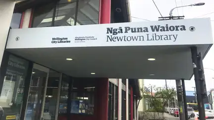
Ngā Puna Waiora - Newtown
Ngā Puna Waiora, the area between Adelaide Road and Riddiford Street, referring to the many streams flowing down the hills in the vicinity of Newtown, from the 'Te Ranga a Hiwi' ridge that runs in a North/South direction from Matairangi (Mt Victoria). The water soaked into the hill and bubbled up to the surface under what is now the new Children's Hospital on Riddiford Street.
Korimako - Ngaio (Cummings Park Library)
Korimako stream, named after the bellbird, is the Ngaio branch of the head streams of the Kaiwharawhara and rises on the southern slopes of Kaukau (Tari-kākā). It flows past Ngaio to join Te Māhanga branch of the Kaiwharawhara at the top of the gorge, a mile and a quarter above its mouth.
Te Takapū o Patukawenga - Tawa
Te Takapū o Patukawenga was a cultivation located in the valley of the Porirua Stream (originally Kenepuru) in the vicinity of the present Takapū Road.
The patch of land here was claimed by the chief Te Patukawenga, of Ngāti Mutunga, who moved into the Waikanae area, from Taranaki, alongside Te Ati Awa and Ngāti Tama in the heke Niho Puta, before proceeding towards Pipitea.
At this place above the Porirua valley, Te Patukawenga exclaimed 'Ko taku takapū tēnei' — this is my belly i.e. place of food supply.
References
- Adkin, G. L. (1959) The Great Harbour of Tara. (pp. 84, 103).
- Dom. 4/6/1929- H M Christie.
Te Awe - Brandon Street
Te Awe refers to white feathers or plumes and has an important cultural tohu for ngā tāngata of Taranaki/Te Atiawa.
The name was gifted to the site by Mana Whenua.
Ōtari - Wadestown
"Place of bird snares".
According to Elsdon Best, Ōtari is the name of the peak of Tinakori Ridge -- other names included Mt Wakefield, Upper Etako trig station, or Wireless Station hill.
The name Ōtari is now attached to a trig station two miles farther inland on the Tari-kākā-Makara Hill ridge, formerly called Te Whārangi ridge.